

Wetlands &
Watersheds
Browse our research
Tell me about...
wetlands


What is a wetland?

Wetlands are areas that have been soaked by water, such as marshes, swamps, bogs, fens, and seasonally flooded forests. [53] A wetland is home to plants and soils that are adapted to water-logged, saturated conditions. Wetlands help lessen the impact of floods and droughts, absorb pollutants, improve water quality, provide habitats for many species, and protect our shorelines.
Wetlands were once abundant throughout Canada, but now cover only about 13% of the nation’s land area. [54] In southern Ontario, only about 30% of the original wetlands remain. The remaining 70% have been converted from their natural state to support alternative uses, such as agriculture or housing. [55]

Photo credit: Jock Rutherford
Did you know?
…that wetlands are the only ecosystem designated for conservation by international convention? [56]

Wetlands as a
carbon sink
How well soil stores carbon depends on many factors, including soil type, vegetation, and climate. [57]
In general, the colder and wetter, the better! Wetland soils tend to be poor in oxygen, which slows decomposition and lets organic matter build up within them. This means that wetlands are particularly useful for carbon sequestration.
The case of the dissapearing wetlands
A recent study found that 95.5 hectares of wetlands were lost in southern Ontario from 2002 to 2010. [58] Most of those wetlands were under 2 hectares in size. These small wetlands are generally not evaluated or designated as significant enough for protection. The study projected that by 2026, our wetland losses may exceed 400 hectares.
But small wetlands play an outsized role in our ecosystems. They act as stepping stones for species moving between larger wetlands, provide critical habitat for amphibians, water birds, and rare plants, and affect how water interacts with the landscape.

Leaving wetlands intact can not only help the environment, it can also save money, too. Researchers modeled an urban site to simulate a major fall flood, comparing damages under conditions where wetlands were maintained in their natural state and where they were replaced with agricultural land use. [59] They found that if wetlands existed in their natural state, the flood damage costs could have been reduced to $84.5 million, compared to the $135.6 million without the wetlands.
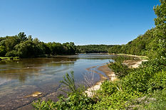
source: mvca.on.ca/lake-huron-shoreline
Wetlands and
climate change
Coastal wetlands, such as those found in along the shores of Lake Huron, “are among the most vulnerable ecosystem types in the Great Lakes.” [60]
A changing climate poses various threats to these delicate areas, including increased surface water temperatures, changing water levels, and increased storm frequency and intensity.
Coastal wetlands provide critical spawning, foraging, and nursery habitat for many species of fish, which are particularly sensitive to both water temperature and dissolved oxygen. [61] Temperature affects how fish grow and reproduce, and oxygen is critical for respiration. Warmer water temperature in wetlands will lead to more rapid decomposition of organic matter. What’s more, the higher the water temperature, the less oxygen can be dissolved in water. Together, these factors have the potential to threaten fish and invertebrate populations, and to lead to dangerously low dissolved oxygen in the water, known as “hypoxia.”

The water levels of Lake Huron are poised to become increasingly variable as the climate changes. Increased water levels can harm aquatic vegetation, while decreased water levels can negatively affect the connectivity between wetlands, tributaries, and the lake, which has impacts on the flow of organic matter. [62] Increased storm surges are likely to bring with them nutrients, sediments, and other contaminants.

Rivers & Streams

Going with the flow.
How will the changing climate affect our rivers and streams? Higher summer and fall air temperatures will increase evaporation, making it likely that summer river flows will be lower than historical observations by the end of the century. [63]


More intense summer storms will likely mean more variability in the flow rate (also called discharge) of rivers. An increase in precipitation is likely to increase nutrients such as nitrogen and phosphorus in rivers and streams thanks to agricultural runoff and sewer overflows.
A 2019 study looked at how climate change over the next century might affect flow rates and other parameters of watersheds in the American Midwest, which included areas around Lakes Huron, Michigan, and Erie. They found that peak daily streamflow is likely to increase due to an increase in precipitation during winter and spring seasons. They note that snowmelt-dominant basins may show less pronounced change, since there is likely to be less snow (and therefore less melted snow runoff) in the spring thanks to warmer air temperatures.
Photo credit: Conrad Kuiper
The authors also conclude that “high-resolution regional climate models dynamically incorporating the Great Lakes are needed to explore these effects in more detail.” In particular, the climate models that they used have a large uncertainty capturing small-scale convective storms, which is a large source of precipitation in the warmer months.


Protecting and managing Ontario's natural resources
Conservation Authorities are community-based watershed management agencies. Their mandate is to protect people and property from flooding, erosion, and other natural hazards, and to conserve natural resources for economic, social, and environmental benefits.
There are 36 Conservation Authorities across Ontario. [64]


Maitland Conservation
Spotlight on Conservation Authorities
What is a watershed?
A watershed is an area of land that catches rain and snow and then drains (or “sheds”) that water into a marsh, stream, river, lake, or groundwater. Watersheds are nested systems, with smaller drainage basins nesting into larger ones. [65]
The Saugeen-Bruce region is located in the Eastern Lake Huron watershed, which in turn is made up of smaller drainage areas such as Saugeen, Maitland, and Bruce Peninsula.


Watershed
Report Cards
Ontario’s Conservation Authorities issue Watershed Report Cards every five years to provide a “check-up” on the health of many of our watersheds, including surface and groundwater quality and the conditions of forests and wetlands.
Water quality in rivers and streams is measured by tracking total and dissolved nutrients, metals, and chloride, as well as monitoring for E. coli and Benthic invertebrates (small aquatic animals that live in river and stream beds).
Wetlands are graded on percentage of wetland cover, while forests are graded on percentage of forest cover, forest interior, and riparian cover (the area between land and a river or stream).

Summary
Most overall grades have not changed since the 2018 report card, although the Beatty Saugeen River and Upper Main Saugeen River areas have improved. Phosphorus grades fell in the South Saugeen River and Lower Main Saugeen River. Benthic invertebrate grades generally improved.

FINDINGS
-
Overall grades range from A (excellent) to C (fair), with mostly (60%) B (good) grades.
-
Most overall grades have not changed from the 2018 report card, however the Beatty Saugeen River, Lake Fringe and Upper Main Saugeen River areas have improved.
-
Phosphorus grades fell in the South Saugeen River and Lower Main Saugeen River. Remaining grades stayed the same.
-
E. coli grades remained mostly unchanged across the watershed, with improvement for the Penetangore River area. Benthic macroinvertebrate grades generally improved.


2023 REPORT CARD
Summary
Water quality grades are generally high. They note that trees near waterways help keep water temperatures cool. With fewer trees, water temperatures can rise, and more pollutants can run off into rivers and streams.

FINDINGS
-
Water quality grades are high, with most watersheds achieving a grade of A (excellent) or B (good).
-
Watersheds that have a lower water quality grade typically have poor forest cover grades as well, specifically poor treed riparian areas along watercourses.


Spotlight on Pine River Watershed Initiative Network (PRWIN)
Based in Ripley, Ontario, the Pine River Watershed Initiative Network (PRWIN) is a non-profit organization with a mission of maintaining clean water and a healthy ecosystem within the Pine River watershed.
Founded in 2000 by a group of concerned citizens, PRWIN has been working with landowners and farmers to implement projects that improve water quality and land health while reducing environmental impact.
PRWIN’s on-the-ground projects include:
Managing runoff and preventing erosion through berms or water and sediment control basins.
Wetland and streambank restorations to enhance water filtration and habitat
Livestock crossings, solar-powered water supplies, and exclusion fencing to protect waterways
Extensive tree planting efforts, including windbreaks afforestation, and reforestation
New this year, PRWIN has launched a juniper planting program along the Lake Huron dunes to help stabilize sand, protecting shorelines from erosion and flooding. The organization is also developing two new initiatives: cover cropping to improve soil health and woodlot ash tree removal to manage forests impacted by the emerald ash borer.
Beyond restoration efforts, PRWIN is committed to environmental education. The organization offers youth programming, school excursions to the McLarty Centre, and an annual 4H Community Planting Day. Often taking place on the first Saturday in May, the planting day is a great opportunity to get involved as a volunteer with PRWIN.
